
Today’s Prices

Grain markets finished higher today with current conditions still somewhat threatening and a crop report coming out tomorrow from USDA.
Grain Market News

High Temperatures

The past weather and current weather are supportive of bullish news, but the forecast is certainly not hinting at additional problems but improvement down the road.
Yesterday’s high temperatures do show some cooler temperatures with mid-70s to lower 80s in the eastern belt but still some heat with 90s in the far western belt into he eastern plains.
Surface Dew Point

This dew point map as of noon today shows extremely dry air in the eastern belt.
Dew points in the middle of June in the 30s and 40s are extremely rare, especially in the eastern belt.
Even though temperatures are only in the mid/upper 70s and lower 80s, evaporation and soil moisture loss are rapid due to the extremely dry air.
7-Day Observed Precipitation

Unfortunately, the eastern belt down into the delta for the most part has missed out on rains over the last week.
Corp conditions likely deteriorating in the eastern belt.
30-Day Precipitation % of Normal

Over the past 30 days this map shows precipitation shown as a percent of normal and you can see almost the entire U.S. corn and bean belt has been below normal.
The exception would be pockets in southwest Minnesota into northwest Iowa.
From eastern Iowa into the eastern belt there are many locations that are red, which means less than 25% of normal.
Drought Monitor Change

That lack of precipitation is also allowing our drought monitor to show an increase in drought in the eastern belt.
This is the drought monitor change over the last 4 weeks.
Anything yellow or tan is where it has gotten worse and anything in green or blue is where it has improved.
Drought has increased 1-2 categories in almost the entire central and eastern belt while drought has improved significantly in areas of the western plains.
U.S. Radar
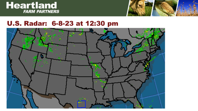
The current radar shows rainfall along that boundary where we have cooler, dryer air to the east and moist air in the western belt.
Along that boundary is where we see some showers and thunderstorms.
7-Day Precipitation Forecast

Anywhere from half to an inch and a quarter is expected in the eastern belt with 1-3 inches of rain possible in the southern Ohio valley down into the delta.
The area that may miss out would be the northern and northwestern belt where generally less than half an inch or less than quarter of an inch is expected.
Outlook

The forecast is nonthreatening as we look further out.
The 6-10 day shows temperatures close to normal with a little warmer in the 8-14 day.
Precipitation is about average in the central and heart of the belt in the 6-10 day and about normal in the 8-14 day.
Grain Market News

U.S. Ending Stocks

May Corn Chart

Corn prices have had a couple of disappointing days.
We posted highs earlier in the week at 5.48 but last night we were down to 5.20.
The good news today is we were able to reverse and close higher at 5.33.
Not only did we close near the daily high but 13 cents off the daily low.
Overhead resistance at 5.48 and chart support at 5.20.
May Soybean Chart

Soybeans have also been carving out a range recently with 11.95, the high earlier this week and today’s low at 11.68.
Today’s close within that range.
We currently have overhead resistance close to $12 with chart support around $11.65.
May KC Wheat Chart

Wheat prices have been extremely volatile, today was no exception.
We made a new low for this move down to 7.82 overnight last night but turned around closing at 8.04.
This puts overhead resistance at 8.47 and chart support at 7.82.
Questions or Comments
